SINGAPORE: Better colour. Sharper images. More business details seen within the map.
These are some of the things people can expect from Google Street View when Singapore has been re-mapped, said Ms Cynthia Wei, Street View Program Manager for Google Asia Pacific, during an exclusive interview with Channel NewsAsia on Monday (Jan 22) to reveal the initiative.
The tech giant’s Street View product was introduced to the country in 2009 and, since then, there’s been yearly refreshes to capture the changes in the city’s landscape. But the focus is on areas where “changes happens frequently” such as the Central Business District, particularly the area where Marina Bay Financial Centre is currently, she added.
However, Google recognises that “transitions are constantly changing” here, such as in areas like Punggol, and there is a need to re-map the country to keep Street View up to date, she said.
As to why do the Street View refresh now, with one car on the streets since Monday and the rest expected to hit the roads by end of the week, Ms Wei said “this is the earliest time slot for the technology” to be brought to Singapore.
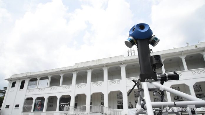
By this she means equipping the Street View cars with the latest rig: Seven cameras with 20 megapixels each, instead of the previous iteration of 15 cameras with five megapixels each.

The WALL-E lookalike camera set-up is now more compact – with seven cameras, instead of the 15 in the previous model. (Photo: Howard Law)
Besides the more compact camera set-up, Google’s juiced-up Street View cars also come with Light Detection and Ranging (LIDAR) sensors, which Ms Wei said allows them to better place the imagery these cars capture during the post-production phase. There are also side-facing cameras, allowing the vehicles to capture street-level storefront data, she added.
LIDAR sensors are used by companies looking to bring autonomous cars to the roads, and it is a vital component as it maps the car’s surroundings in 3D by bouncing laser beams off the environment around it.
Perhaps the biggest innovation, at least for the drivers of these cars, is the fact that the camera rig is now around 60 per cent lighter than its predecessor and can be automatically lowered from its operational height at the push of the button.
Ms Wei shared that the previous version required drivers to manually lift the cameras on to the roof racks, and secure it using several screws. “So when there’s a sudden thunderstorm, the drivers will have to scramble to get the rig off the roof!”
The Google executive shared that her team is hoping the data collection for this latest re-mapping initiative will wrap up within three months, but that’s the “ideal timeframe” given the fickle nature of the tropical island’s weather.
“If even a raindrop ends up on the image, then we can’t use it.”
Additionally, Google will apply artificial intelligence and machine learning to the images collected, which would enhance the quality of the data collected, she said, adding that given the other post-production processes, she cannot say if the latest Street View maps can be seen by year’s end.
Ms Wei did note that Singapore is the first Southeast Asian country to have the latest Street View technologies, and it is the first time the team has brought three of such cars to map the country when usually one would have sufficed. This initiative is done in conjunction with the partnership with local running group JustRunLah! to capture more than 30 running routes in Singapore, the executive said.
Runners Paviter Singh and Ben Flint carrying the trekker. (Photo: JustRunLah!/Larry Laydn)
It will bring the car to the other parts of the region, but discussions are still underway, she added.
So the next time you see a car with a blue, WALL-E lookalike camera on its roof driving by, know that it is helping to bring the Singapore landscape into the palm of your hands via Google’s Street View app.


