SINGAPORE: Towering thunderstorm clouds coupled with powerful vertical air currents were the reason for the hailstones seen in the northern areas of Singapore on Tuesday, said the Meteorological Service Singapore (MSS).
Replying to Channel NewsAsia’s queries in an email, MSS on Wednesday (Jan 31) said that yesterday’s thunderstorm clouds which formed over northern Singapore reached a height of 14km. Typically, thunderstorm clouds only reach a height of 10-12km.
“Towering thunderstorm clouds form when there is very strong daytime heating of the land surface, coupled with wind convergence,” it added.
“These clouds have powerful downdrafts that cause some hailstones to reach the ground quickly before melting.”

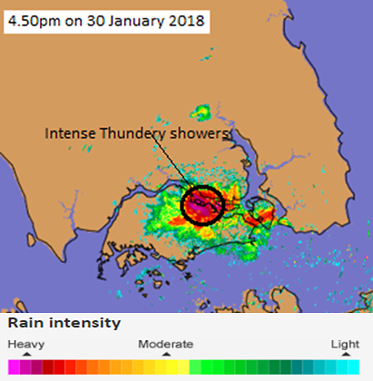
The weather radar image shows the areas affected by intense thundery showers at 4.50pm. (Photo: MSS)
Hailstones are formed within most thunderstorm clouds when raindrops freeze at high levels. They then grow in size as they are tossed by the strong updrafts and downdrafts – or strong vertical air currents – within the clouds.
In warmer and tropical countries like Singapore, hailstones formed in the upper atmosphere usually melt before reaching the grounds, said MSS.
However, at times when there are very strong downdrafts, the hailstones would reach the ground before they completely melt.
MSS said that yesterday’s rain was heaviest in the north, with the highest recorded 30-minute rainfall at 46.6mm from 4.55pm to 5.25pm.
The strongest recorded wind gust was at 70.9km per hour at Sembawang at around 5pm, it added.
“Sightings of hailstones in Singapore have been reported every few years on average,” said MSS, with the last reported sightings of hailstones in October 2014 and June 2013.
“The impact of climate change on the frequency of hailstone events in the tropics is a subject that requires further study,” MSS added.


